2026 Glacier National Park Itinerary 3-5 Days
I recently spent several weeks traveling through Montana and Glacier National Park in my campervan. Hands down, Glacier National Park my favorite US National Park to date.
It’s home to some truly stunning views and hikes, including my favorite hike in the United States — Grinnell Glacier!
However, between the parks popularity and crowds, as well as the ever-changing reservations and policy updates it can be a tricky park to get reservations and plan a trip.
In this post, I’m sharing what I’ve learned about building the best Glacier National Park itinerary, as well as how to optimize your time in the park and avoid crowds.
In this article:
- Glacier National Park itinerary for 1 to 5 days (+ printable version)
- The best hikes & scenic drives
- Tips for planning your trip (shuttle, wildlife, parking) and avoiding crowds
- Where to stay & eat
Disclaimer: This article features some affiliate links. I only endorse things I’ve personally used or that come highly recommended by trusted peers. If you purchase anything I mention using my referral links from Amazon, REI or other retailers I may receive a small commission. However, there is never extra cost to you. You can read more here. Thank you for your support.
Glacier National Park Overview
✈️ How To Get There: Fly into Glacier Park (30 min), Missoula (2.5 hr), or Bozeman (5.5 hr)
⛰️ Glacier Must-See: Going-To-The-Sun Road, Avalanche Lake, & Highline Trail
💵 Entrance Fee: $35 or free with an America The Beautiful Pass
🛌 Where To Stay: Lake McDonald Lodge (West side) or Many Glacier Hotel (East side)
TIP: I recommend booking your rental car with Discover Cars. They search across the major rental companies to find the best rate and let you cancel for free up to 48 hours before pickup, so you can grab a good rate now without stressing if your plans change.

Glacier National Park Itinerary Overview
2026 Glacier National Park Updates
🎟️ There are no timed-entry reservations required in 2026
🅿️ Parking at Logan Pass is limited to 3 hours
🚌 Going-To-The-Sun Rd has ticketed shuttle services (details here)
Glacier National Park is massive. It can take more than 2 hours to drive between different areas of the park, so careful planning of your Glacier National Park itinerary is essential for avoiding unnecessary hours driving back and forth.
The map below shows the 8 areas within Glacier. In this article I’m sharing my Glacier National Park itinerary for 5 days (or fewer), and recommend focusing on the highlights; Lake McDonald, Saint Mary, Many Glacier and Two Medicine areas.

By focusing on the areas above, in yellow, you’ll have time to see all the best views, drive Going-To-The-Sun Road, and have access to the best hikes in Glacier National Park… all without spending several hours driving each day.
While the other areas of the park, in blue, do have some unique hikes, they’re far more remote (some only accessible by dirt road or border crossing) and, in my opinion, aren’t where I’d focus my time if I only had one week or less in Glacier.

All of the nearest airports for Glacier National Park are located to the West of the park. For that reason, I recommend starting your Glacier National Park itinerary at West Glacier, near Apgar Village and Lake McDonald.
3, 4 & 5 Day Glacier National Park Itinerary
With 3 days in Glacier National Park, spend your first day near Lake McDonald, your second day driving Going-To-The-Sun Road with a few hikes near Logan Pass, and your third day in Many Glacier.
With 4 days, add a second day in Many Glacier. The most stunning day hikes are located there, including Grinnell Glacier and Iceberg Lake.
However, the best option is 5 days in Glacier National Park, which will give you a day to spend in Two Medicine.
This Glacier National Park itinerary is stackable, meaning you can follow the first 3 days only, or all 5 days. I’ve also outlined alternative options for shorter hikes or things to do if parts of the park are closed.
Glacier National Park Map
Use this map to plan your Glacier National Park itinerary! I’ve labeled items by day (noted by color) as well as by activity type (noted by icon).
You can download this map for easy reference during your trip, even without cell service.
How To Use This Map:
1. To open in a new tab, click [] in the top right corner of the map.
2. To save to your Google Maps account, click ☆ (you must be signed in to Google).
3. To use during your trip, open Google Maps on your phone, select “You” from the bottom bar, scroll down and click the maps icon for a list of your saved custom maps.
🚐 Plan The Ultimate Road Trip In A Campervan
Are you curious about van life? This trip is the perfect route to give it a try!
Outdoorsy is a great peer-to-peer campervan rental site (like Airbnb) with tons of van layouts and prices across the US! Native Campervans is great if you prefer to rent from a company with 24/7 roadside assistance for peace of mind.
Not sure about where to park for the night? Don’t stress!
Download my Guide To Finding Free Campsites e-book or checkout The Dyrt to find unique stays.
NOTE: Going-To-The-Sun Road has vehicle size restrictions; vehicles cannot exceed 21 feet in length, 8 feet in width or 10 feet in height.
Glacier National Park One Day Itinerary

Day 1 Highlights:
- Avalanche Lake Trail
- Trail of the Cedars
- Huckleberry ice cream in Apgar Village
- Paddle on Lake McDonald
Arrive via West Glacier as early as possible. Entrance lines to get into Glacier start to back up by 9 AM, but I recommend arriving even earlier (before sunrise, if possible) because parking inside the park becomes full by 7 AM.
The earlier you arrive, the less time you’ll spend circling for a parking spot.
Morning Hike To Avalanche Lake & Trail Of The Cedars

Distance: 6 miles
Elevation Change: 785 ft
Rating: Moderate
Time Needed: 2-3 hours
Location: Going-To-The-Sun Road
As soon as you enter the park head directly to Avalanche Lake Trail. This is a great way to start your trip to Glacier National Park, and it’s best done earlier in the day before it gets too crowded.
Avalanche Lake Trail is 6 miles and takes you to a beautiful lake with several waterfalls in the backdrop. The view at the lake is one of the most iconic photo spots in Glacier National Park.


<< Read More: Hiking Avalanche Lake Trail >>

🥾 Trail Of The Cedars Hiking Guide
Distance: 1 mile
Elevation Change: 50 ft
Rating: Easy
Time Needed: 30 minutes
Location: Going-To-The-Sun Road
Conveniently, Trail Of The Cedars is right next to Avalanche Lake, and they share a parking lot. I recommend hiking this short 0.9 mile loop while you’re there.
This is one of the most accessible hiking trails in Glacier National Park, and is stroller and wheelchair friendly. The walk is flat and follows a raised wooden boardwalk through the cedar forest (which smells amazing!)
TIP: If arriving before 8 AM is not feasible, I recommend adjusting your itinerary so you can hike these trails after 3 PM when the crowds lessen.
Lunch And Shopping In Apgar Village


After, head back towards Apgar Village to explore the shops and eat lunch at Eddie’s Cafe & Mercantile. Definitely save room for a scoop of huckleberry ice cream!
Everything in Apgar Village is very walkable. It’s best to park at the visitor center, where there is a massive parking area, and take the short bike path into the village.
While you’re there, check out some of the unique gift shops and restaurants:
- Cedar Tree Gift Shop is the largest gift shop in Glacier and a great place to pick up souvenirs.
- Montana House features local art, jewelry and handcrafted gifts.
- Eddie’s Mercantile is both a general store with snacks and camping essentials, as well as a counter service restaurant service breakfast, lunch and dinner. They are famous for their huckleberry ice cream and homemade huckleberry pie.
Afternoon Paddle On Lake McDonald

Spend the afternoon on Lake McDonald. You can swim in the lake, or rent boats from Glacier Park Boat Co.
Boat rentals are available from Apgar Village or Lake McDonald Lodge. Since you’re already there, I find that rentals from Apgar Village tend to be easier due to parking limitations.
Reservations are available, but only for rentals starting at 10:15 AM. If you’re hiking Avalanche Lake in the morning, you’ll probably miss this.
Instead, stop by and put your name on the first-come, first-serve list when you arrive in Apgar Village. That way, by the time you’re done shopping and eating you’ll be closer to the top of the list.
🛶 Lake McDonald Boat Rentals:
Boats Available To Rent: Kayaks, Rowboats, Paddleboards, Motorboats
Rental Locations: Apgar Village or Lake McDonald Lodge
Cost: $25-$45 per hour
Reservations: Only available for 10:15 AM, otherwise first-come, first-serve (excludes paddleboards and rowboats)
Dinner And An Evening Walk Around Johns Lake

In the evening, make your way to Lake McDonald Lodge at the north end of the lake. There’s a large parking area that tends to be less busy after 3 PM. There are two restaurant options for dinner.
- Jammer Joe’s – casual grill and pizzaria
- Russel’s Fireside – rustic lodge-style dining
Alternatively, you can pop out of the park to West Glacier for dinner. There are many restaurants in town.
- Glacier National Pizza – casual counter service with gluten free options
- Glacier Highland Restaurant – casual comfort food
- Belton Chalet Dining Room – historic lodge with locally-sourced food
🥾 Johns Lake Loop Hiking Guide
Distance: 2.1 miles
Elevation Change: 190 ft
Rating: Easy
Time Needed: <1 hour
Location: Lake McDonald
Finally, end your day with a peaceful walk around Johns Lake, near Lake McDonald Lodge.
It’s a half mile walk from the lodge to the trailhead, or you can drive. Parking is limited but is usually less crowded in the evening.
The loop trail is a little over 2-miles and fairly flat. It follows McDonald Creek with views of McDonald Falls and the lake.
In the evening, when the trail is quieter, you’re likely to see wildlife, like Moose, along the water.
Best Places To Stay In West Glacier
I recommend spending your first night near West Glacier so you can cut down on drive time and be well positioned for Going-To-The-Sun Road the following day.
There are many options in and near the park.
- Lake McDonald Lodge – historic lodge on the lake, inside the park.
- West Glacier Cabin Village – literal steps from Glacier National Park, offers private, well appointed cabins.
- Belton Chalet – a charming, historic chalet next to Glacier’s west entrance.
- Glacier Guides Lodge – an all-inclusive lodge with bike rentals and guided rafting, backpacking, biking and more.
Save this article
Enter your email address and I’ll send it straight to your inbox!
You’ll also receive my monthly newsletter filled with helpful National Park planning tips.
Glacier National Park Two Day Itinerary

Day 2 Highlights:
- Going-To-The-Sun Road
- Hidden Lake
- Highline Trail
- St Mary & Virginia Falls
Get another early start on your second day in Glacier National Park so you can enjoy Going-To-The-Sun Road before it gets crowded.
This area of the park is jam-packed with the best things to do in Glacier! However, food and gas options are very limited so I recommend packing a picnic lunch and fueling up before you start your drive.
Scenic Drive Along Going-To-The-Sun Road

The road is 52-miles long (one-way) and cuts through some of the most stunning scenery in the park.
There are several Going-To-The-Sun Road stops you’ll want to be sure you check out:
- The Loop – one of the most scenic views, once you pass through the tunnel you’re under a mile from this spot – keep an eye open for the small pull-offs as you approach.
- Weeping Wall – 5 miles past The Loop you’ll drive under a waterfall that flows over the road. You cannot stop here.
- Big Bend – just past Weeping Wall, where the road curves. Roadside parking and restrooms are available, and the valley views are incredible.
- Oberlin Bend – 2 miles farther, and lesser known, there’s a short trail here and plenty of mountain goats to see up close! Temperatures are cooler here due to the elevation.
Shortly after Oberlin Bend, you’ll come to Logan Pass – the pinnacle of Going-To-The-Sun Road and home to some of the best hikes in Glacier National Park.
TIP: One of the best ways to experience Glacier National Park is with your own tour guide. This self-guided driving tour is easy to download, and automatically plays as you approach each landmark (it uses GPS to know where you are! No cell service required.)
Think of it as your personal tour guide who shares great tips, interesting history about Natives and early settlers, fascinating geological explanations and highlights hidden gems you might have missed on your own… except this is completely on your own schedule and for a fraction of the cost of a tour.
If this is your first trip to Glacier National Park, I highly recommend this self-guided tour (it also works if you’re riding the park shuttle!):
Morning Hikes At Logan Pass

Hidden Lake Overlook and Highline Trail both start from Logan Pass Visitor Center. There’s a fairly large parking lot there, but it usually fills up by 8 AM during the summer. The earlier you arrive, the easier it’ll be to find parking.
Plan to spend a few hours at Logan Pass. But keep in mind there is a 3-hour parking limit beginning in 2026.
3 hours is enough time to hike Hidden Lake Overlook or a section of Highline Trail.
However, if you want to hike down to Hidden Lake or the full length of Highline Trail you’ll need more than 3 hours. This means you’ll need Glacier shuttle tickets.
TIP: Shuttle tickets ($1) are released 60 days in advance. They’re extremely competitive so set a calendar reminder and book them as soon as they’re released.
Hidden Lake Overlook

🥾 Hidden Lake Overlook Hiking Guide
Distance: 2.7 miles
Elevation Change: 550 ft
Rating: Moderate
Time Needed: 1-2 hours
Location: Logan Pass
Hike to Hidden Lake Overlook first. It’s a great place to spot wildlife, especially in the morning.
I recommend hiking Hidden Lake first, because Highline Trail can be icy (even in summer!) so it’s best to give it some time for the sun to melt the ice.
Hidden Lake Overlook is 2.7 miles total, and takes you to a raised platform where you can see Hidden Lake below.
The trail is a mix of wide and well maintained dirt, as well as sections of raised wooden boardwalk. It’s not steep, but there is consistent, mild elevation gain up to the overlook.
Hidden Lake takes you through an alpine meadow and is a great place to see wildflowers, even well into late summer. There were still many when I visited in mid-September.


If you’re up for a longer hike you can continue past the overlook down to the lake. In total, the full Hidden Lake Trail is 5.1 miles.
It’s rated as a moderate hike, mostly because the last quarter mile is very steep with lots of steps down to the lake. The full hike to Hidden Lake took me around 3 hours to complete.
<< Read More: Hiking To Hidden Lake Overlook >>
Highline Trail

Distance: 15 miles
Elevation Change: 2,620 ft
Rating: Hard
Time Needed: up to 8 hours
Location: Logan Pass
Across the street from the Logan Pass visitor center parking lot is the trailhead to Highline Trail.
This is one of the most iconic hikes in Glacier National Park, and has indescribable views of the valley. Pictures don’t do it justice!
There are several options for hiking Highline Trail. Out-and-back, one-way, or just the initial section if you’re short on time.
In total, Highline Trail is 15 miles out-and-back (7.5 miles if you’re hiking it one-way).
The trail starts at Logan Pass and heads down to The Loop, passing a spur trail to Grinnell Glacier Overlook (which adds 1.5-miles.)
It’s possible to get reserved shuttle tickets for drop-off at one end, and pick-up at the other if you plan to hike point-to-point.
However, most hikers opt to do a portion of the trail, instead of the entire thing. With the parking restrictions at Logan Pass, this is the easiest way to experience this hike without dealing with advanced shuttle tickets.
From Logan Pass, the views open up almost immediately. The first two and a half miles are fairly flat, as well.
However, you’ll come to the chain section almost immediately. This is where the trail is very narrow, and follows the cliff wall. The chains were installed to keep you from slipping.


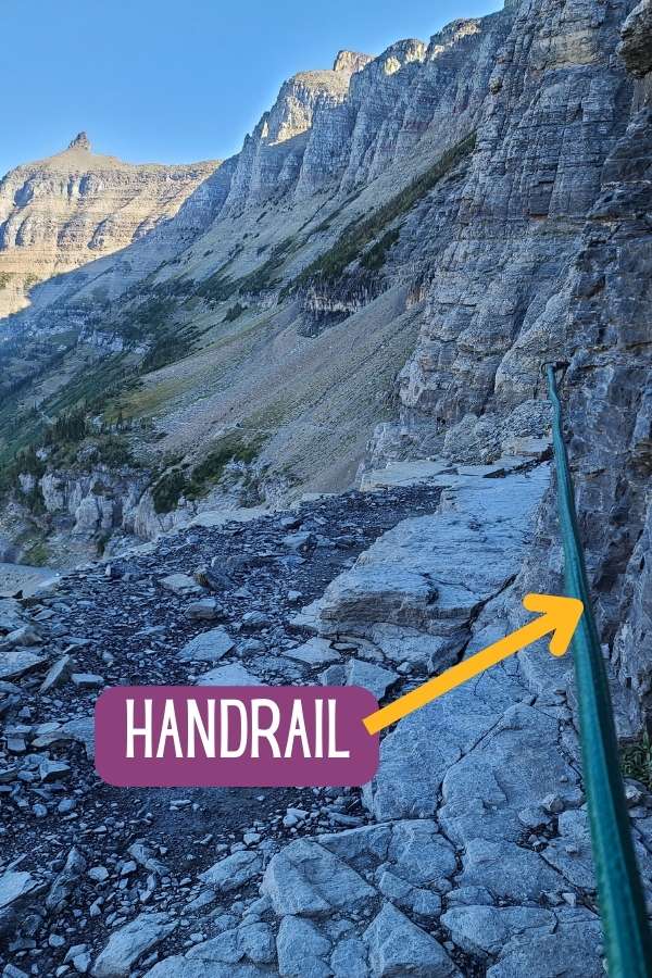
If you have a fear of heights, or challenges with balance, I would not recommend this hike.
The first mile or so is also shaded well into the day, so ice (possible even in summer, due to the elevation) can make this trail tricky first-thing in the morning. I recommend bringing traction devices.
I also recommend bringing gloves. Not only can it be cold, but the metal chains can be especially chilly.
TIP: Plan for a little extra time on this trail. The narrowness makes it difficult for two-way traffic in some areas, so there can be congested areas that take longer to get through.
After hiking, there’s a great spot about half a mile from Logan Pass that’s perfect for a picnic lunch… aptly named Lunch Creek.
There’s a small waterfall next to the road, and a short path you can follow through the forest. However, there are no picnic tables so pack a blanket!
St Mary & Virginia Falls

🥾 St Mary & Virginia Falls Hiking Guide
Distance: 3.1 miles
Elevation Change: 470 ft
Rating: Moderate
Time Needed: 1.5–2 hours
Location: Saint Mary
After leaving Logan Pass, keep heading east on Going-To-The-Sun Road toward St Mary. It’s about a 15-minute drive from Logan Pass.
St Mary & Virginia Falls are two of the most popular waterfalls in Glacier National Park. They’re both located on the east shore of Saint Mary Lake.
In total, it’s a 3.1-mile out-and-back trail to see both waterfalls. You’ll come across St Mary Falls first before continuing to Virginia Falls.
Like just about anywhere along Going-To-The-Sun Road, the parking at St Mary & Virginia Falls is extremely limited and generally full by late morning. However, it tends to clear around 3 PM.
If parking at St Mary Falls is full, you have a few options; head into the town of St Mary for an early dinner (several restaurants just outside the parks entrance) before coming back later, or use alternate parking that requires a slightly longer hike.
The trails along Saint Mary Lake all connect, so it’s possible to drive further East and park at Sun Point parking lot, or any of the roadside pull offs.
This map shows the additional parking options in yellow, and the hiking trail in green:

Dinner In St Mary
The East side of Glacier National Park has objectively fewer options for restaurants and hotels.
However, Two Dog Flats is located near Rising Sun (inside the park) and serves a large menu of American cuisine.
Additionally, just past the St Mary entrance is a small town with several more choices for dinner:
- Frogs Cantina – Mexican grill with counter service and outdoor seating
- Rising Sun Pizza – pizza and wings
- Kip’s Beer Garden – bar and grill
Best Places To Stay In East Glacier
As the rest of this Glacier National Park itinerary focuses on the eastern half of the park, the most convenient hotel options are in St Mary or Many Glacier.
Unfortunately, there aren’t a ton of options, so you’ll want to book many months in advance, if possible. Staying on the east side will save you at least 2-hours of driving (one-way) for the remainder of your trip.
Places to stay in St Mary:
- Rising Sun Motor Inn – comfortable rooms and cabins inside the park, along the shores of Saint Mary Lake
- St. Mary Village – steps from Going-To-The-Sun road
Places to stay in Many Glacier (1 hour drive, and location for day 3 activities)
- Many Glacier Hotel – historic lodge inside the park, on the lake
- Swiftcurrent Motor Inn – rooms and cabins available, next to several popular hikes
Alternatively, there are several great options for camping in Glacier National Park in this area.
3 Days In Glacier National Park Itinerary

Day 3 Highlights:
- Grinnell Glacier Trail
- Swiftcurrent Nature Trail
- Apikuni Falls
- Swiftcurrent Pass
With 3 days in Glacier National Park, I highly recommend seeing as much of the Many Glacier area as possible. I found this area of the park just as stunning (if not more so) than Going-To-The-Sun road. However, many of the views require a hike.
The good news is this area of the park can be a bit less crowded, and they’ve recently completed a construction project to expand parking.
As an added perk, many of the trailheads start from the same area so you won’t have to drive much (or fight for parking) while you’re here!
Morning Hike To Grinnell Glacier & Swiftcurrent Nature Trail

🥾 Grinnell Glacier Trail Hiking Guide
Distance: 11 miles
Elevation Change: 2,070 ft
Rating: Hard
Time Needed: 5–6 hours
Location: Many Glacier
If I could only pick one thing to do while visiting Glacier National Park it would be the hike to Grinnell Glacier.
I had no idea how epic this hike would be, and I’m not sure I have words to describe how incredibly beautiful the entire trail is. It’s just one stunning view after another!


Grinnell Glacier Trail is 11 miles out-and-back and over 2,000 feet of elevation gain. It’s rated as hard, and the elevation change might seem intimidating, but I barely remember noticing. That gain is spread out over many miles, and I saw all types of abilities on this hike.
<< Read More: Hiking Grinnell Glacier Trail >>

🥾 Swiftcurrent Nature Trail Hiking Guide
Distance: 2.6 miles
Elevation Change: 130 ft
Rating: Easy
Time Needed: <1 hour
Location: Many Glacier
The first portion of Grinnell Glacier Trail overlaps with Swiftcurrent Nature Trail, which loops around Swiftcurrent Lake.
On your return from Grinnell Glacier, take the trail to the right (East) at Swiftcurrent Lake. You’ll know you’re where the trail splits because you’ll see the Swiftcurrent dock. This takes you to Many Glacier Hotel along Swiftcurrent Nature Trail.

In total, Swiftcurrent Nature Trail is 2.6 miles. Because it shares the first 0.7 miles with Grinnell Glacier Trail, it adds just under 2 miles to your hike.
Swiftcurrent Nature Trail will take you right past Many Glacier Hotel which has a few options for lunch, including The Ptarmigan Dining Hall, Swiss Lounge, and Heidi’s Snack Shop & Espresso Stand (grab-and-go).
The map below shows the two trails, and the junction where they split.

Afternoon Hike To Apikuni Falls

🥾 Apikuni Falls Trail Hiking Guide
Distance: 1.8 miles
Elevation Change: 600 ft
Rating: Moderate
Time Needed: 1–1.5 hours
Location: Many Glacier
After lunch, head to Apikuni Falls. It’s a shorter hike, just under 2 miles out-and-back, and takes you right up to the base of the waterfall.
Parking at the trailhead is very limited (only about 15 spots for vehicles), so it’s usually easier to walk over from Many Glacier Hotel.
This adds a mile and a half each way, and you can walk along Rte 3 or take the Saddle Horse Corral trail which is parallel to the road and ends at the trailhead parking.
The trail up to Apikuni Falls is rated as moderate, mostly due to its steady elevation gain.
Evening Wildlife Spotting

In the evening, head to Swiftcurrent Village. It’s about 2 miles down Rte 3, at the end of the main road through Many Glacier.
Nell’s at Swiftcurrent Motor Inn is a good place to grab a casual dinner before exploring the many trails in this area.

🥾 Swiftcurrent Pass Trail Hiking Guide
Distance: 13.7 miles
Elevation Change: 2,440 ft
Rating: Hard
Time Needed: 6.5–7.5 hours
Location: Many Glacier
I recommend a leisurely hike along Swiftcurrent Pass Trail to Redrock Falls and Bullhead Lake.
In total, the full trail is almost 7 miles one-way, but the first 4 miles are flat and pass multiple lakes (which are a great place to spot wildlife near dusk).
You can hike as much or as little of the trail as you’d like. After a long day of hiking, it’s a nice way to spend the evening.
The first lake you come to is Fishercap Lake (almost immediately), then Redrock Falls (1.5 miles to reach) and Bullhead Lake (about 3.5 miles to reach).
I recommend spending time at Bullhead Lake if you want to see moose! – they frequently come to the water here, especially around dusk.
TIP: Bring a headlamp if you’ll be walking back after dark!
Alternate Options For Day 3

Instead of an afternoon hike, join a guided horseback tour in Many Glacier. The Swiftcurrent Loop is an hour long trail ride that leaves from Many Glacier Hotel at 12:45 PM each day.
Expect to pay around $110 per person. The trail takes you to stump lake, which is located between Swiftcurrent and Lake Josephine. This is an excellent place to spot some moose!
Or, if you only have 3 days in Glacier National Park, consider replacing Apikuni Falls and Swiftcurrent Pass with another long hike. Cracker Lake and Iceberg Lake are stunning hikes (if you’re sticking around for a second day in Many Glacier, put these on your itinerary for day 4, instead!)
Best Places To Stay In East Glacier
I recommend booking the same accommodation for nights 2, 3 and 4 because the Eastern side of Glacier has limited options, and all the items on this Glacier National Park itinerary are relatively close together for days 2 through 5.
Places to stay in St Mary:
Places to stay in Many Glacier
Glacier National Park Itinerary 4 Days

Day 4 Highlights:
- Cracker Lake
- Iceberg Lake
With a second day in Many Glacier, add a few longer hikes to your itinerary. These two trail options are incredibly beautiful and worth the effort.
Morning Hike To Cracker Lake

🥾 Cracker Lake Trail Hiking Guide
Distance: 12.6 miles
Elevation Change: 1,600 ft
Rating: Hard
Time Needed: 5.5–6.5 hours
Location: Many Glacier
Cracker Lake is a 12.6 mile out-and-back trail that takes about 6 hours to complete. It’s one of the most beautiful lakes in Glacier National Park, and a great place to see wildlife, including grizzly bears (from a distance) and moose.
The trail ends at Cracker Lake, which is a brilliant turquoise color. While the hike is longer, it’s not very difficult (aside from a few creek crossings).
It’s also a fairly easy hike without significant elevation change as it follows the creek bed.
After hiking Cracker Lake trail, stop for lunch at Many Glacier Hotel, or head up the road to Swiftcurrent Village for lunch at Nell’s. The trailhead for your afternoon hike is near Swiftcurrent Village.
Afternoon Hike To Iceberg Lake

🥾 Iceberg Lake Trail Hiking Guide
Distance: 9.7 miles
Elevation Change: 1,450 ft
Rating: Moderate
Time Needed: 4.5–6 hours
Location: Many Glacier
Iceberg Lake is 9.7 miles out-and-back. It gets it’s name from the icebergs that float in the lake year-round. The trail has easy elevation gain the entire way, with only two short, but steep sections.
For the most part, this hike is exposed, so be sure to pack sunscreen and a wind-breaker.
There are some water crossings, so you’ll also want waterproof hiking boots. And, there can be snow and ice on the trail well into July, so traction devices are a good idea.
Bear sightings are extremely common on this trail, so carrying bear spray is a must.
Glacier National Park Itinerary 5 Days

Day 5 Highlights:
- Pitamakan Pass
- Running Eagle Falls
On your final day in Glacier National Park, head towards Two Medicine area, just south of St Mary.
This area of the park is less visited and tends to have fewer crowds.
Morning Hike To Pitamakan Pass

🥾 Pitamakan Pass Trail Hiking Guide
Distance: 15 miles
Elevation Change: 2,745 ft
Rating: Hard
Time Needed: 7–9 hours
Location: Two Medicine
Pitamakan Pass is a 15 mile hike with significant elevation gain (just under 3,000 ft). The trail is remarkable and takes you to views in Glacier National Park most visitors don’t see!
Plan for at least 7 hours to complete this hike. The trailhead is located at Two Medicine campground, just north of Pray Lake.
From the ridge line you can see Pitamakan Lake, Seven Winds Of The Lake, Oldman Lake, Boy Lake and Lower Two Medicine Lake. It’s really an incredible view with so many lakes and mountain peaks in all directions.
I recommend packing a lunch and eating it on the trail. There aren’t any restaurants located in Two Medicine.
Afternoon Hike To Running Eagle Falls

🥾 Running Eagle Falls Trail Hiking Guide
Distance: 0.6 miles
Elevation Change: 30 ft
Rating: Easy
Time Needed: 30 minutes
Location: Two Medicine
After Pitamakan Pass, head back east along Two Medicine Road to Running Eagle Falls. The trail is a 0.6 mile loop that’s flat and one of the more accessible trails in Glacier National Park (friendly for wheelchairs and strollers!)
Running Eagle Falls is also referred to as Trick Falls. When the water flow is high, usually from snow melt in spring and early summer, it appears to be one waterfall.
However, as the flow tapers off later in the season you’ll notice that it’s actually two falls stacked on top of each other.
For dinner, I recommend heading in to East Glacier Park, just outside of Two Medicine. The Burger Box, East Glacier Stageline Pizza, and Two Medicine Grill are all great options after a long day of hiking.
Tips For Planning A Trip To Glacier National Park
There’s a lot of detail that goes into planning the perfect Glacier National Park itinerary. It’s one of the more challenging parks to plan logistically due to parking limitations, the short season, and massive crowds to avoid.
These are the best tips I’ve learned for planning a trip to Glacier National Park and making the most of your time there!
Get Text Updates About Roads, Trails & Campgrounds
There are a lot of moving pieces for planning a trip to Glacier National Park – like when Going To The Sun Road officially opens (usually early July, but varies by year), and which trails are open or posted/closed due to wildlife.
The best way to stay updated on changes to trails and roads in Glacier is to sign up for their free text alerts.
Get Glacier National Park Updates
Text 333111 with
- “GNPROADS” for road updates
- “GNPTRAILS” for trail updates
- “GNPCGS” for campground updates
You’ll receive a text confirming your request, with the option to register for email alerts instead.
Current status’ are also available on the NPS website.
Download Maps Ahead Of Your Trip
There is nearly no cell service in Glacier National Park, and even in spots where you might pick up LTE signal, you won’t have enough data to load maps.
I recommend downloading offline maps before your trip. That way, the data is stored on your phone and you can still use GPS navigation even without a cellular connection.
Google Maps is my favorite option for offline maps and driving navigation. For hiking trails, I like AllTrails.
In order to use AllTrails maps offline you’ll need an AllTrails+ subscription. The paid version also includes alerts if you accidentally get off the trail (so you won’t get lost!) and the option to share your location with friends or family.
AllTrails+ costs $36 per year, but you can get 30% off with my discount code EVERYWHERE30.
Rent Or Borrow Bear Spray In Glacier

You need to carry bear spray on absolutely every hike in Glacier National Park. Bear sightings are extremely common. However, bear encounters are not (so don’t be too scared!)
Unfortunately, bear spray is not something you can fly with. It can’t be in your carry on or in your checked bag.
It’s also fairly expensive to purchase ($30-$40) if you’re only going to use it during your trip to Glacier, then have to leave it behind for your return flight home.
There are many options for renting or borrowing bear spray in Glacier.
Most vacation rentals and hotels offer bear spray rentals. Check with your accommodation ahead of your trip to see if these will be available to you during your stay.
There are several local shops that rent bear spray:
- Glacier Outfitters locations (Kalispell airport, Apgar Village, West Glacier, St Mary Village) – $10/day or $28/week
- Bear Spray Shack vending machines (Whitefish, Columbia Falls, East Glacier) – $10/day
My personal favorite option is the Sharing Shack, located along the main road in Columbia Falls (about 20-minutes west of Glacier National Park).
The Sharing Shack is a completely free option to borrow bear spray and other hiking or camping gear (available on a first-come, first-serve basis.)
Stop by, pick up what you need, and be sure to return it when you’re done. All items in the shack are donated and meant to be a free resource for visitors.
The best way to keep up with current inventory is to follow their facebook page.

What To Pack For Glacier National Park
Glacier National Park has some large temperature variations, even well into the summer. The difference in elevation across the park will also mean significant changes in weather, depending on which part of the park you’re in.
Layers are super important for any trip to Glacier, regardless of the season. During my visit in early September I was in shorts and a t-shirt in Apgar Village, and a winter jacket, hats and gloves the next day at Logan Pass.
Even if you’re visiting Glacier in the summer, bring an insulated jacket, a hat (or something to cover your ears), and gloves.
My recommendation: I like the Nano Puff from Patagonia. Not only is it extremely warm, but it packs down quite small so it’s easy to pack in a carry on or day hiking backpack.

Additionally, hikes in Glacier National Park are incredibly beautiful, but they tend to be longer hikes with significant elevation gain. A good pair of hiking boots, a 16-22 liter daypack and trekking poles are must-haves.
Hiking boots that cover your ankles will provide more ankle support, which also saves your knees from hurting, offer more insulation in cold weather, and keep more water out of your boots.
My recommendation: these trekking poles on Amazon are the ones I have, and have held up great for many, many years. My favorite hiking boots are made by Danner. They are incredibly supportive, have almost no break-in period, and hold up well for years.
I also cannot emphasize the importance of good hiking socks enough! This is hands down the best thing you can do to prevent blisters. Look for a high-quality wool sock.
I rave about Darn Tough socks — yes, they’re a bit more expensive ($25/pair), but I’ve had mine for a decade and they still look brand new. Plus, Darn Tough comes with a lifetime warranty so you won’t have to buy them again!
TIP: Wool socks are odor-resistant, which means you can rewear them for multiple days. Sounds gross! But it’s true. I only own 4 pairs of Darn Tough socks, and even for multi-day backpacking trips I only pack 2 pairs (one for daytime, one for sleeping.)
I also recommend having these blister plasters in your daypack, just in case you start to get a blister. They’re the only thing I’ve found that stops a blister once it starts!
For sunrise or sunset hikes in Glacier, you’ll need a good headlamp. I prefer one that is rechargeable so I don’t have to carry around spare batteries.
Traction devices are also a good idea, especially if you’re visiting Glacier National Park in early July or late September through October. Snow and ice at elevation can be tricky to navigate without proper footwear.
If you’re new to hiking, check out my guide to the best women’s hiking gear for beginners. I offer budget-friendly options because building up a good set of hiking gear can be pricy when you’re just starting out!
Check out all of my hiking essentials on my Amazon page here.
For a complete list, download my free Glacier National Park packing guide.
Glacier National Park Itinerary FAQs
Save this article
Enter your email address and I’ll send it straight to your inbox!
You’ll also receive my monthly newsletter filled with helpful National Park planning tips.
Additional Planning Guides For Glacier National Park
- Guide To Glacier Shuttle Tickets
- Going To The Sun Road Map With Stops
- Best Hikes In Glacier National Park
- Where To Stay In Glacier National Park
- Glacier National Park Camping
- Best Glacier National Park Waterfalls
- Bozeman to Glacier National Park Road Trip
- Dog-Friendly Hikes & Hotels
Travel Planning Resources
These are the resources I use and recommend for planning your next trip:
Accommodations: Expedia (hotels), VRBO (vacation rentals)
Flights: Skyscanner
Rental Cars: DiscoverCars and Outdoorsy
Tours & Excursions: Viator and GetYourGuide
Travel Insurance: SafetyWing
Credit Card With Travel Points: Chase Sapphire Preferred


We are planning a trip in early September. I came across your blog and it is filled with tons of info. Thank you so much for sharing!
I think September is the best time to visit Glacier National Park! So glad you found this helpful – thanks for the kind note! Enjoy your trip 🙂
Outstanding guidance ! Thank you!
Have a great trip Joe!